The term 'guerrilla rainstorm' is one that most folks have probably never heard of. This is because the term's use has mainly been confined to Japanese media outlets. For residents of Tokyo, the term has become a common weather term, as many of these localized downpours occur in and around the vicinity of Japan's largest city. These rainstorms that seemingly pop up out of nowhere have been occurring in increasing numbers over the city in recent years. Severe urban flooding and even hailstorms have been documented with some of these seemingly rogue events. They are seen as a bit of a mystery due to their sudden development and major local impacts. Predicting these events can prove to be a futile endeavor as well, as weather forecast models aren't able to pick up the mesoscale (small-scale) dynamics that go into creating these storms. All of this lends to the mystique of the guerrilla rainstorm. Even though the term is not an 'official' meteorological term, it does refer to an event that can be explained via the laws of meteorology.
The Urban Heat Island
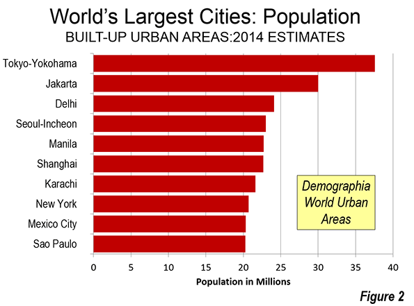
Tokyo and its surrounding area is the most populated region in the world as over 37 million people call the Tokyo metropolitan area home. The population of Tokyo is so impressive that it trumps the population of the second largest city in the world, Jakarta, Indonesia by over 10 million. The Tokyo metropolitan area covers an impressive 3,300 square mile area. This makes it over twice the size of Rhode Island. As you would expect, city development is expansive, with tightly packed buildings and streets comprising much of the landscape. The effect that this has on local weather is what meteorologists refer to as the urban heat island effect. Cities of any scope are subject to this, but Tokyo experiences a much stronger urban heat island effect due to its impressive size.
To understand the urban heat island effect, the meteorological term, albedo, must be understood. Albedo is the term used to describe the amount of the sun's energy a surface is able to reflect back into space. Energy that doesn't reflect back into space becomes absorbed by the surface, which allows heat to build up. The lower the albedo is, the more the surface is able to heat up, thereby heating the air around it. Snow has the highest albedo of any surface, as over 80% of the sun's energy reflects back up to space when snow is present. Green grass and forest areas are lower, with 15-25% of the sun's energy getting reflected back to space. City buildings and roadways have a much lower albedo, with 2% or less of the sun's energy reflecting back up to space. This means that the majority of the sun's energy is absorbed, thereby heating up the buildings and roadways. The end result is an abundance of heat that concentrates over urban areas. The urban heat island effect is certainly not confined to daytime hours either. At night the effects can be enhanced. This is because the excess heat that builds up in buildings and roadways during the daytime hours will continue to radiate into the city throughout the night. When you add in the effects of exhaust heat from all the air conditioners that run through the night, the impact is magnified.
The Sea Breeze from Tokyo Bay
The Pacific Ocean resides on the southeast side of Tokyo, and thereby makes that part of the city subject to a sea breeze. Sea breezes are a common occurence for coastal areas, especially when water temperatures are commonly colder than daytime temperatures over adjacent land masses. While large bodies of water, like the Pacific Ocean, see little or no change in temperature during the day and night, land masses heat up quickly during the day and cool off at night. As the land heats up quickly during the day, air rises (due to the natural buoyancy of hot air) and eventually creates a convergence of air aloft. This intern creates a localized high pressure zone above the land, while an area of low pressure develops near the surface. Meanwhile over the adjacent body of water, little or no air is rising (due to the relatively cooler air temperatures found near the water), resulting in locally higher pressure just above the water, compared to that over the land. Because air will inherently move from high pressure to low pressure, a sea breeze develops, thereby transporting a cool, moist air mass inland. The greater the temperature difference between land and sea, the stronger the sea breeze will be. A neat animation of the sea breeze from NOAA can be seen here.

Image Courtesy: Vaughan Weather
The Sea Breeze/Urban Heat Island Connection
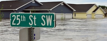
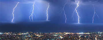
The hottest months of the year in Tokyo arrive in July and August. However, some of the first heat waves of the season can arrive during the month of June. Therefore, the sea breeze is typically the strongest during these hottest times of the year, as the land to sea temperature difference is maximized. During those sweltering days of summer, the urban heat island effect makes the metropolitan area of Tokyo a relative 'hot spot' compared to areas around it. This mass of hot air that accumulates in the city can create an updraft of heat (remember hot air is less dense than cool air). At the same time, a strengthened sea breeze will kick in during these 'stagnant' summer days. As the sea breeze heads into Tokyo, it brings a relatively cool, moist air mass into the southeast side of the city. As the sea breeze gets into the city, it can be pulled into the updraft of heat found over the city. This draws moist and cool air into the updraft, which results in clouds and eventually localized rainstorms. When the updraft is strong enough, even hail may form. Otherwise locally heavy rainfall can be expected. Rainfall amounts of over 4 inches an hour have been reported in some instances. This can create major issues with urban flooding. Urban landscapes inherently create extra runoff, due to the lack of green space, thereby leaving the formidable task of drainage to city sewer systems.
The science behind guerrilla rainstorms is similar to what causes sea breeze thunderstorms each summer in areas such as Florida. However, the dynamics of the sea breeze are changed when it interacts with one of the largest urban heat islands in the world. The impressive height and stature of the buildings throughout Tokyo act as a blockade to the sea breeze. This lends to the variance in where these rogue rainstorms occur, as the sea breeze is deflected by the urban landscape. Some theories suggest that in some instances the sea breeze may actually split and deflect to the north and south of the city, only to converge on the opposite side. This would explain some of the varied locations that these events have been seen.
More research will likely continue on this topic in order to gain a better understanding of how these rainstorms form. Unfortunately, pegging where these localized rainstorms develop would be nearly impossible, due to all the small-scale dynamics that would have to be resolved. Because of this, the guerrilla rainstorm will likely continue to be thought of as an enigma. Whether or not these events some day gain any level of predictability, popularity of the term 'guerrilla rainstorm' (which won the title of Japanese word of the year in 2008) will likely continue.

A guerrilla rainstorm douses a portion of Tokyo